Jiju Peethambaran†1 and Ruisheng Wang‡1,2
1Geospatial Intelligence Lab, Department of Geomatics Engineering, Schulich School of Engineering, University of Calgary, Canada
2 Beijing Advanced Innovation Center for Imaging Technology, Capital Normal University
Computer Graphics Forum 2017
1Geospatial Intelligence Lab, Department of Geomatics Engineering, Schulich School of Engineering, University of Calgary, Canada
2 Beijing Advanced Innovation Center for Imaging Technology, Capital Normal University
Computer Graphics Forum 2017
Abstract
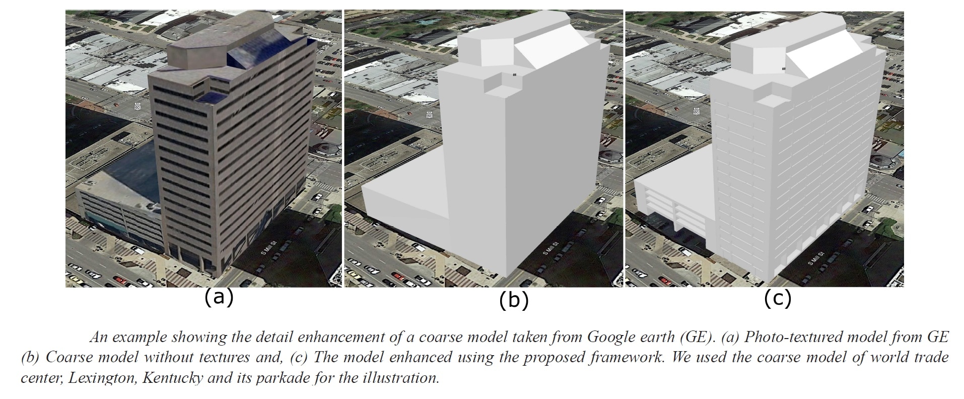
Buildings with symmetrical façades are ubiquitous in urban landscapes and detailed models of these buildings enhance the visual realism of digital urban scenes. However, a vast majority of the existing urban building models in web-based 3D maps such as Google earth, are either less detailed or heavily rely on texturing to render the details. We present a new framework for enhancing the details of such coarse models, using the geometry and symmetry inferred from the LiDAR scans and 2D templates. The user defined 2D templates, referred to as coded planar meshes (CPM), encodes the geometry of the smallest repeating 3D structures of the façades via face codes. Our encoding scheme, take into account the directions, type as well as the offset distance of the sculpting to be applied at the respective locations on the coarse model. In our approach, LiDAR scan is registered with the coarse models taken from Google earth 3D or Bing maps 3D and decomposed into dominant planar segments (each representing the frontal or lateral walls of the building). The façade segments are then split into horizontal and vertical tiles using a weighted point count function defined over the window or door boundaries. This is followed by an automatic identification of CPM locations with the help of a template fitting algorithm that respects the alignment regularity as well as the inter-element spacing on the façade layout. Finally, 3D boolean sculpting operations are applied over the boxes induced by CPMs and the coarse model, and a detailed 3D model is generated. The proposed framework is capable of modeling details even with occluded scans and enhances not only the frontal façades (facing to the streets) but also the lateral façades of the buildings. We demonstrate the potentials of the proposed framework by providing several examples of enhanced Google Earth models and highlight the advantages of our method when designing photo-realistic urban façades.
Buildings with symmetrical façades are ubiquitous in urban landscapes and detailed models of these buildings enhance the visual realism of digital urban scenes. However, a vast majority of the existing urban building models in web-based 3D maps such as Google earth, are either less detailed or heavily rely on texturing to render the details. We present a new framework for enhancing the details of such coarse models, using the geometry and symmetry inferred from the LiDAR scans and 2D templates. The user defined 2D templates, referred to as coded planar meshes (CPM), encodes the geometry of the smallest repeating 3D structures of the façades via face codes. Our encoding scheme, take into account the directions, type as well as the offset distance of the sculpting to be applied at the respective locations on the coarse model. In our approach, LiDAR scan is registered with the coarse models taken from Google earth 3D or Bing maps 3D and decomposed into dominant planar segments (each representing the frontal or lateral walls of the building). The façade segments are then split into horizontal and vertical tiles using a weighted point count function defined over the window or door boundaries. This is followed by an automatic identification of CPM locations with the help of a template fitting algorithm that respects the alignment regularity as well as the inter-element spacing on the façade layout. Finally, 3D boolean sculpting operations are applied over the boxes induced by CPMs and the coarse model, and a detailed 3D model is generated. The proposed framework is capable of modeling details even with occluded scans and enhances not only the frontal façades (facing to the streets) but also the lateral façades of the buildings. We demonstrate the potentials of the proposed framework by providing several examples of enhanced Google Earth models and highlight the advantages of our method when designing photo-realistic urban façades.
Results
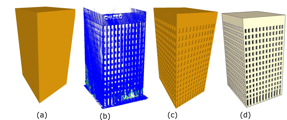
Symmetric façade. An example of high rise building with many number of façade elements exhibiting extensive symmetry. We have shown the coarse model taken from Google earth (a), the corresponding LiDAR scan (b), enhanced model generated by the proposed framework (c) and a manually textured model (d). The proposed framework modeled all the façade details located on the frontal and two lateral walls of the building. The model use only two templates to model 520 façade elements.
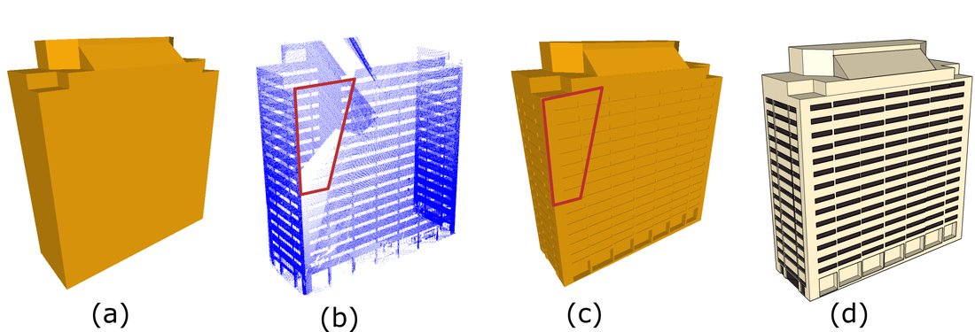
Modeling from occluded scans. Occluded region, marked using red boundary in the LiDAR data, has been successfully
reconstructed by our framework.
reconstructed by our framework.
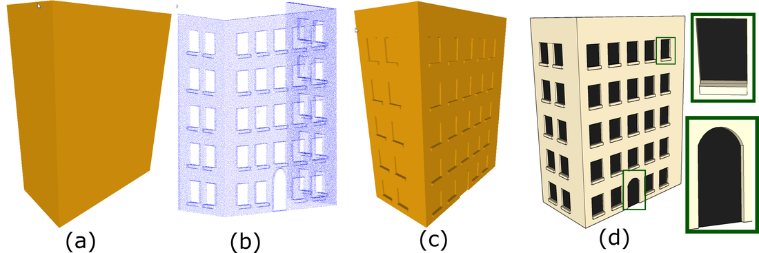
A model with protruding structures and arch door. This example clearly indicates the potentials of coded planar meshes in modeling non-rectangular structures such as arch doors (shown in inset).
Bibtex
@article{cgf:2017,
title = {Enhancing urban facades via LiDAR based Sculpting},
author = {Jiju Peethambaran and Ruisheng Wang},
year = {2017},
journal = {Computer Graphics forum} }
title = {Enhancing urban facades via LiDAR based Sculpting},
author = {Jiju Peethambaran and Ruisheng Wang},
year = {2017},
journal = {Computer Graphics forum} }
Acknowledgements
The authors thank Dr. Ruigang Yang for providing the liDAR scan of Lexington, Kentucky and Dr. Chao-Hui Shen for providing
the source code of adaptive partitioning [SHFH11]. We thank the anonymous reviewers for their valuable comments and feedback
for improving the paper.
the source code of adaptive partitioning [SHFH11]. We thank the anonymous reviewers for their valuable comments and feedback
for improving the paper.
Resources

Paper (8.2MB)
|

Data
|

Video
|
